Mancos Main Street Bridge Replacement Project F.A.Q.
by Heather Alvarez | April 26, 2021 3:41 pm
When is the construction taking place?
Construction is slated to begin May 3 and it is estimated to continue until the end of August. Work hours will be Monday – Friday, 7 a.m. to 5:30 p.m. If needed, work may take place on Saturdays.
What are the traffic impacts?
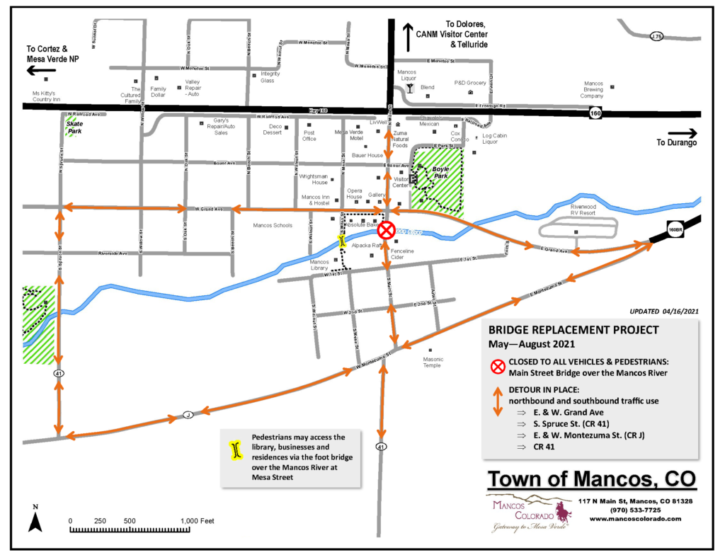
From May through August, the Main Street bridge will be closed to all motorists and pedestrians. Motor vehicle traffic will need to utilize easterly and westerly detour routes via East and West Grand Avenue, South Spruce Street and East and West Montezuma Street. Pedestrians may access businesses, the library and residences via the foot bridge over the Mancos River at Mesa Street. (Please refer to the map below.)
Will customers still be able to access businesses?
Business access will not be blocked by the construction. However, patrons may need to take a walking or driving detour (see map) since the bridge will be closed throughout this period. Wayfinding signs are being created to aid in business access. Patrons of the Bauer Bank Building and the Absolute Bakery will have access from the adjacent sidewalk. Fenceline Cider can be accessed using the pedestrian bridge near the library or the vehicle detour route (see map).
Will there be parking downtown?
Yes. The regular downtown parking will be available except for the six spaces on the north side of the bridge on Main Street. If needed, the parking lots at Boyle park and at Pioneer Plaza (next to the Opera House) maybe used.
Will I still be able to picnic at the lot on the corner of Grand and Main?
Yes, this lot will generally be open for picnics except for occasional use for construction staging. However, due to its proximity to the construction, visitors may wish to utilize Boyle park. The Ballantine Lot (next to the Mancos Common Press) is also available for daytime use.
Why now?
The Town has been working to replace this bridge since 2015 because bridge inspection reports showed the bridge has significant structural problems. The load rating of the bridge was reduced until a new bridge could be constructed, however the load restrictions have been disregarded by many drivers. Due to the existing condition of the concrete and other bridge components, and the existing rate of deterioration, the project cannot be delayed any longer due to the health and safety of the community. Additionally, There are many environmental clearances and temporary rights of way that have an expiration date, and the funding is expiring December 31, 2021. Extending any or all of these items requires additional processes and procedures with no guarantee that any of the deadlines on these items will be extended.
How much will this project cost?
The total cost of the project is approximately $2 million. The town has secured a $1 million grant from CDOT and a $193,000 grant from DOLA.
Why is the bridge being replaced?
A study by the town’s engineering firm, SEH, and the Colorado Department of Transportation determined that there is severe deterioration in the deck soffit and girders. Additionally, there are spalls with exposed rebar in the exterior bays of the deck totaling approximately 45 feet, longitudinal cracks, and honeycomb voids with exposed rebar. Thus, the bridge is failing and needs to be replaced as soon as possible to ensure the continued safety of those who use it.
When the existing bridge was built one hundred years ago, much of the traffic consisted of horse drawn wagons. Currently, it is estimated that 750 vehicles cross it every day. The bridge has two lanes, yet it is narrow by today’s standards and has no sidewalks. Pedestrian safety is also a concern. Visitors and locals cross it both on foot and on bikes, competing with motor traffic to visit homes, businesses, the library, and the school.
Will there be dust and noise?
We do not expect a lot of dust, there will be some noise from the jackhammers, machines and the trucks mostly during the demolition stage. No Dynamite will be used in this project. The Town of Mancos will be managing traffic control.
What improvements are being made? Will the new bridge reflect the historical nature of downtown Mancos?
The bridge will be brought to current load and rating standards and will be widened to allow for two lanes and two sidewalks to ensure the safe crossing for pedestrians and motorists alike. Work will also include the installation of conduit for future fiber optics. To address its ability to withstand the next hundred-year flood, the bridge will be ten feet longer and riverbed improvements will be made. The area between the bridge and the Bauer Bank Building will be reinforced, as this structure will need strengthening as well to maintain its integrity. In keeping with Mancos’ western historical roots, the concrete sides will resemble the bricks from the historic bank building across the street and every effort will be made to incorporate the iconic 1912 stamp which exists on the current bridge.
What is the history of the current bridge?
According to the Mancos Times’ archives, sustained and heavy rains in October of 1911 led to the largest, most damaging flood in the written history of Mancos and surrounding areas. The flooding caused the Mancos river to change its channel. Buildings, property, and the prior Main Street bridge were destroyed. A year later, the town constructed a reinforced concrete bridge to replace the wooden structure damaged by the flood. Today, this 1912 bridge is still the primary connection between the north and south sides of town, bearing the weight of hundreds of cars and heavy, modern trucks which traverse it daily.
Downloadable PDF: MAP_DETOUR_Mancos Bridge Replacement_04.16.2021
Source URL: https://www.mancoscolorado.com/mancos-main-street-bridge-replacement-project-f-a-q/